Detailed Itinerary
Day 1: Reckong Peo (7513 ft) to Shurting (11188 ft) via Thangi and Lumber (9501 ft)
3 hrs jeep drive from Peo to just before Lumber. 8 kms, 2 hrs trek from drop point to Shurting.
Reckong Peo is the last major village so after all arrangements for the trek is done drive to Lumber which is 60 kms drive from Peo. Lambar is a small village in Pooh Tehsil in Kinnaur District. This beautiful drive takes you into the heart of the Tirung Valley along the Tirung Nala offering a glimpse of the rural life along the way.
The drive itself becomes an adventure once you reach Thangi. The jeep will drop you just 2-3 kms short of Lumber, which is the last motorable point. Get off here and walk down to Shurting, also known as Shruling. Keep to the left side of the river and follow the kaccha-stone road ahead. After 30 minutes into the hike the trails narrows and passes through loose soil and scree. After going around for another 15 minutes the trail now gradually starts to descend. You will find yourself going through a series of gradual ascents and descents for another 15 minutes till it descends to the river bed.
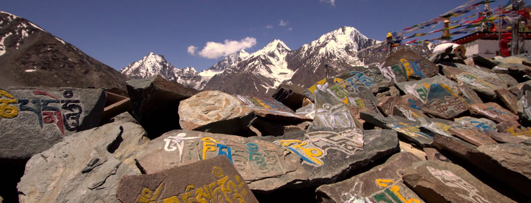
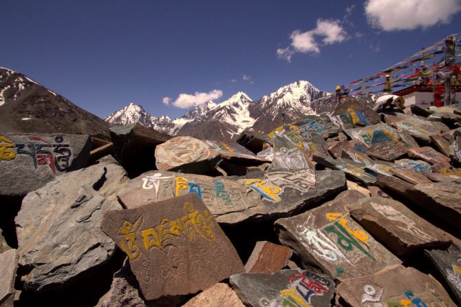
The trail continues by the river through a narrow valley with limited view. You pass by small boulders and after 20 minutes of easy walking you see a huge cave in the rock on the other side of the river at a height of above 75 100 ft from the ground. Colorful prayer flags are seen fluttering in the wind and are said to bring happiness, long life and prosperity to the flag planter and those in the vicinity.
Continue for another 5 mins and you will cross a bridge over the Tirung nala which takes you on the trail to Shurting. The serene hike suddenly becomes lively with the gushing sound of the Triung nala under the bridge. Keep yourself on the right of the river and follow the trail.The trail passes through bushes and shrubs covered with pink flowers. Wild Himalayan roses are clusters of silvery pink flowers that darken as they age.
Within 10 minutes you will reach the open grounds of the Shurting (11188 ft). Just before Shurting are empty settlements usually used by the horse/ khacchar owners or shepherds. For Kunu you need to continue on the right bank before the bridge. Just past Shurting, the stream coming from the Shimdong pass to Tibet joins the main river on the right. Kunu (11155 ft) can be seen amidst gently sloping fields. The traditional Parikrama route requires one to visit Kunu. The stretch which is around 8 kms from Lumber to Shurting is relatively easy and takes around 2 hours. Shurting is an ITBP checkpost as you are very close to the ITBP border. The border is less than 30 kms away. Beyond this point begins the restricted area and it is not possible for foreigners (Non-Indians) to visit Khimokul la, giving access to Tibet. You can camp next to the ITBP campsite or proceed to Charang Village which is 6 kms from here.
Day 2: Shurting(11188 ft) to to Camp-I (before Lalanti) (13780 ft) via Charang (11483 ft)
shurting to Charang, 6 km,1.5 hrs. Charang to Camp-I (before Lalanti) (13780 ft), 10 km, 7hrs.
There are two trails that go from Shurting. The one that goes ahead follows the Tirung Nala passing Charang village. The other trail goes right from the ITBP checkpost. The trail that goes to right up in the hills is unstable with landslides, steep piles of scree and deep streams of water flowing down the hillside. Stay on the right side of the river and follow the Triung Nala. The old trail will lead you from Shurting to the Charang village. You will also see a trail on the other side of the stream that goes to the Kunu village. Carry on the trail for 10 minutes passing through the riverbed as the river widens and divides into many small streams.
After 30 minutes into the hike, you will see that the trail now gradually starts to ascend. The trail rises above the river as the valley widens and you see some excellent views of the Racho group of peaks, including the highest peak in the Kinaaur area, Rangrik Rang (21500 ft). You need to continue on the trail that moves along the right of the valley towards Charang Village. It takes about 1hour before you see the beautiful white stupa of the Rangrik Monastery on the left. Rangrik Monastery is one of the most sacred monasteries in Kinnaur. You will see the trail passes through the Charang guest house. Here you can have quick snacks and fill your water bottles as you may not find water for another 4-5 hours. This is also the last village on the trail and the trek from here on will be in complete isolation.You can purchase some last moment supplies here but do not expect much.
Keeping the Charang Guest house to your right follow the trail that moves upwards bypassing the Charang Village. The climb continues for 10 minutes till you reach a point from where the trail takes a U turn and you see the guest house on to your right now. The trail now gradually starts to ascend. After 30 minutes you come across a couple of incomplete stone shelters that look like the 4 walls of a hut. This is used by the shepherds. Keeping the stone shelter to your left continue on the trail that moves to top of the ridge for another 45 minutes till you see a vast expanse of the valley. Look out for the magnificent snow clad peaks. The peak on the left is Rangrik Rang peak. You will come across a stone structure that stands 2 feet tall. Stones stacked one over the other indicate the way. The trail passes through a series of small boulders that appear like a flat table along with a few bushes here and there. Continue on the trail for another 30 minutes till you see Lalanti pass in front of you.
Lalanti La is visible from a long distance as you see huge stone structures along with the multi coloured Buddhist prayer flags that indicate the pass.The trail up to the Lalanti pass is gradual but long (2-3 kms). It takes around 2.5 3 hours to reach the pass.
Lalanti pass lies in the upper Shurting valley at about 14764 ft. From the pass follow the trail which curves towards your left. The trail zigzags down to the valley and follows the stream thereafter. This is the tributary of Tirung Nala that comes from Shurting. Proceed down towards the stream as the trail gradually descends. After 15 minutes into the hike the trail becomes very thin and narrow. Watch your steps as it can get slippery with all the mud. You will see that the trail disappears many times because of landslides in between. After hiking on the trail for another 15 minutes you will cross a thin stream coming from the top.The trail down the hill is unstable with landslides, steep piles of scree and streams of water flowing down the hillside.
After 1 hr into the hike the trail gradually ascends for a few minutes and then descends steeply through a gully formed by rocks on either side. Proceed down for another 30 minutes till you are just a few meters above the riverbed. The trail gradually ascends and passes through green pastures. Wade through the green pastures for 30 minutes till you come across a narrow stream coming from the top. You will also see stone structures used by shepherds for temporary shelter. You can camp here or proceed to Lalanti which is 1 hour, 2-3 kms from here. It takes 3-4 hours to reach Camp-I from Lalanti pass and around 6 hours from Charang Village.
Day 3 : Camp-I (before Lalanti, 13780 ft) to Camp-II 8 kms, 4 hrs.
The relatively easy gradient today coupled with manageable overall distance gives you ample opportunity to explore the area around and soak in every nuance of this extraordinary trail. Keep yourself to the left side of the river and follow the trail ahead. The trail passes through a grass patch and shrubs covered with red stem and yellow flowers. If lucky you could see colorful butterflies and some exotic Himalayan birds on the way. After 30 minutes you will come across a small stream that comes from the hill top and merges with the river below.As you cross over, you will see a small pasture land full of knee high bushes and boulders. Continue on the trail that gradually starts to ascend. You will find yourself going through a series of gradual ascents and descents for another 30 minutes till you see a vast expanse of the valley. The trail passes through small boulders and bushes. Look out for the magnificent snow clad peaks on either side. The peak on the right is Saro 19997 ft and another unnamed peak 20500 ft.
Proceed down on the trail that goes to the river bed hopping over a lot of small boulders. In the distance you see a stone structure that stands 2 ft tall on the other side of the river which you will pass after 20 minutes into the hike. This indicates that the Lalanti campsite is near. Do not cross the stream as it is very deep. Look for the Lalanti campsite which is on the other side of the stream.
Lalanti campsite has a tin shed that is used by the pilgrims that come on the parikrama. The campsite is situated on a flat meadow ground a little above the river. You can see the yaks grazing on the slope a little above the Lalanti meadows. Proceed on the trail for another 30 minutes till you see the Lalanti campsite across the stream. Here the stream is broken down into several small streams, so choose the stream that is small and shallow to cross over. Keep yourself to the right side of the river and follow the trail ahead bypassing the Lalanti campsite. After 20 minutes into the hike the trail gradually starts to ascend.You will come across a stone structure indicating the way. Proceed down on the trail that gradually descends to the meadow.
After 30 minutes of relatively easy hike the trail passes through grass meadows covered with little yellow flowers along the stream. Follow the trail through loose stones. You will find yourself again climbing up for another 30 minutes followed with a level-walk of 30 minutes. After a series of gradual ascents and descents you come across a meadow with stone markings that stand 5 feet tall. You will see huge flat boulders covered with colorful flowers. You can camp here tonight. The panoramic view from the campsite is commanding as you see snow clad peaks on either side of the valley. To acclimatize yourself it is a good idea to explore the valley. Bird lovers can see a variety of Himalayan birds while exploring the campsite. If you are lucky you can encounter wildlife as well.
Day 4 : Camp-II (13780 ft) to Charang La Base (15748 ft) 7kms 4hrs
Today is a relatively easy day for trekking.Proceed ahead with a nice level walk along the stream. Keep yourself to the right of the stream. After 30 minutes into the hike the stream broadens. You will encounter a shallow section where you will have to cross the ice cold river barefoot. The trail gradually ascends and changes from plain meadows to rocky terrains. After around 15 minutes you come across two structures indicating the way. You will find yourself going through a series of gradual ascents and descents on loose rocks. It is very easy to miss the trail here. Keep walking towards the left side of the valley. After another 20 minutes you will come across loose rocks and huge scattered boulders making the ascent difficult.
After 1 hour into the hike you can see the Charang la pass at a distance. Charang La is a muddy patch with a slight depression with snow ridge on one side and rock ridge on the other. Proceed on the trail for around 20 minutes and you can see the rocky terrain now changes to glacier moraine. After 30 minutes of level walk, you will again be required to ascend the moraine ridge. Look for the stone structures at the end of the moraine ridge. You can see the trail now descends down. After 15 minutes of hike you come across a small pond. You will find yourself going through a series of gradual ascents and descents for another 30 minutes till you see a vast expanse of the valley.
Breath taking views of clear sky and snow clad peaks welcome you. In the midst of grey and brown terrain occasionally you all come across small green bushes with yellow flowers. You can get lucky and get to encounter colorful butterflies and some exotic Himalayan birds at this height as well. As it is going to be a short walk today you can enjoy the luxury to click as many photos and videos as required. Proceed on the glacier moraine for another 30 minutes till you see huge boulders and a pond formed by the glacial water. You will see the trail passes through huge boulders. The trail has stone markings all throughout to guide the way. After walking around 30 minutes on the boulder trail look out for a 25 ft huge boulder that has stone marking and a red flag indicating you are very near the Charang la base.
You can see the flag from a distance as it sits atop a huge boulder.You can also see a commanding view of mountain ranges covered with snow on either side. On the left ridge you can see an overhanging edge of snow also called cornice. On the right ridge you can see a peak that looks as sharp as a needle. Continue on the trail for another 30 minutes till you reach a huge glacial lake. Look for two huge boulders of around 30 feet near the lake. In front of the boulders you see a small stone temple that has a few trishuls. Trishul or trident is the primary weapon of Lord Shiva. It depicts the power of Lord Shiva. Many pilgrims who come for Kinnaur Kailash parikrama worship Lord Shiva, offer prayers and seek His blessings. You can camp near the boulder besides the glacial lake. To acclimatize you can go around the glacial lake and check the peaks visible from here.
Day 5 : Charang La base 15750 ft to Charang La 17198 ft to Chitkul 11352 ft , 7kms 9 hrs
Todays trek is more challenging as you climb up the Charang La pass .The top muddy patch visible the previous day is Charang La. This is the most difficult day of the trek due to a lot of altitude gain and a steep descent. The trail goes through glacier moraine, snow bridges (thin layer), rocky terrain and huge boulders so be very careful and follow the guide. Proceed ahead on the left side of the valley as the trail goes parallel to the snow ridge. The trail is covered with snow in patches.
Proceed on the rocky terrain for 15 minutes until you reach the snow bridge. You will encounter a tricky section where you will have to cross the snow bridge which is extremely thin at some places. Look for a stone structure just after the snow bridge indicating the position from where it can be best crossed. You can fill in your bottles here as this is the last place that you will find water. There is no water on the trail for next 5-6 hours. You can see the trail continues in the direction of Charang Pass.The trail passes through huge boulders and some hard snow patches. After 45 minutes of boulder hopping you reach the snow slope just below the muddy patch.
You can see the snow slope has a steep gradient of around 60-70 degrees. This section can be tackled without use of ropes / ice axe, however it is recommended that you carry them especially if you are an inexperienced trekker. You need to continue zigzagon the snow slope for around 1 hour till you reach the muddy patch.The birds-eye view of the valley below is amazing from here. The slope is challenging so you have to be very careful where you stop. A fall will take you directly to the glacial stream below so avoid any risks.
You can see the final trail of around 150 mtr after the snow patch is made up of loose rocks and plenty of scree. You will need to keep some distance between two people on this trail. After 30 minutes of hike you reach the pass. The view from the pass is breathtaking and memorable. Have quick snacks, chocolates, dry fruits here as it is still a long way ahead.
The trek down to Chitkul is long and you need to cover around 5578 ft of steep descent. It is around 6-7 kms and takes around 6 hrs.The route towards Chitkul curves towards the right side of the valley. Proceed down for 45 minutes as the trail passes through rocky terrain and loose boulders. You can see stone structures at regular intervals on the route indicating the way down. Keep yourself to the right of the valley and proceed down for another 45 minutes till you reach the plains. You can see the plain is covered with hard snow. Cross the snow patch and keep moving right.
The trail alternates between snow patches and rocky terrain. Proceed ahead by following the laid out trail on the right side of the valley for another 1 hour till you reach the end of the plains and the trail descends down. Another 1 hour of of steep descent on the rocky terrain will take you to a stream that comes from the top. You will see the trail gradually moves down towards the right.The trail passes through grass patches and shrubs. Wade through the trail for 30 minutes as it broadens. You will see Chitkul village on the left.